Sonia Das
Geospatial Specialist
Urban Planning & Mobility | Remote Sensing | Python
What's new
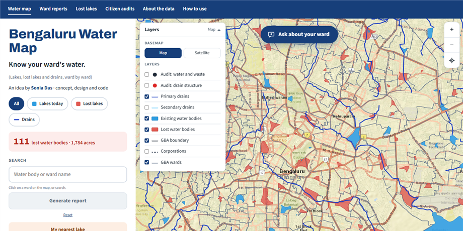
Bengaluru Water Map
A ward-by-ward map of Bengaluru's lakes, lost lakes and stormwater drains, built on data from Building a Resilient Bengaluru. Generates printable ward reports and reports for any uploaded KML area.
About Me
My work over the past ten years has focused on applying geospatial analysis to urban planning, mobility, and archaeology across research institutions, consulting projects, and interdisciplinary collaborations. I work extensively with QGIS, ArcGIS Pro, Google Earth Engine, and Python to build workflows, dashboards, and spatial decision-support tools.
Most recently, I worked with WSP Consultants India on transport and mobility projects for UK infrastructure planning, and before that at Mod Foundation in Bengaluru on urban systems, stormwater drain mapping, and citizen-audit workflows. Earlier research experience at NIAS and NTRO involved remote sensing and geospatial analysis for landscape archaeology, using satellite imagery, DEM analysis, and historical spatial datasets.
Alongside technical analysis, I enjoy communicating spatial insights through interactive visualisation, dashboards, and story maps — turning complex spatial data into tools people can actually use. I am based in Bengaluru, India.
Career at a Glance
Geospatial data scientist with domain expertise in urban planning and resilience, intelligence and archaeology, with community-engaged fieldwork and survey design.
-
Urban Resilience, Mobility & Community Engagement
Mod Foundation, WSP
Stormwater drain citizen audits and Kobo/ODK survey design, maps for public exhibitions on urban water and mobility, urban growth analysis from historical satellite imagery, and transport modelling for UK infrastructure planning.
-
Defence & Government
NTRO, Govt. of India
Published image services and dashboards in ArcGIS Pro, ran geospatial analysis in Python, R and Earth Engine, and wrote user manuals for GIS tools.
-
Archaeology
NIAS, IISc Campus
Remote sensing and GIS for landscape archaeology across 10+ sites in India: DEMs from Cartosat stereo data, NDVI and LULC mapping, and GPS fieldwork.
Skills
-
GIS & Remote Sensing
- ArcGIS Pro, ArcGIS Online, ArcGIS Experience Builder
- QGIS, SNAP (SAR data)
- ERDAS Imagine & LPS photogrammetry — DEMs from Cartosat stereo imagery
- Google Earth Engine
-
Programming
- Python, R, JavaScript
- Excel for data analysis
-
Python for Mapping & Cloud-Native Geospatial
- Matplotlib, CartoPy, Contextily
- Folium, Leafmap, Streamlit
- XArray, DuckDB, STAC, Dask
-
Fieldwork & Citizen Science
- GPS fieldwork
- Kobo Toolbox and ODK for citizen-audit data collection
-
Research & Funding
- Grant writing and proposal development
- Funded research: BSF Small Grants Programme, SERB, ISRO
- Peer-reviewed publication — 5 journal articles, 2 book chapters
-
Web & Portfolio Tools
- GitHub and GitHub Pages
- Static site generators (MkDocs)
-
AI-Assisted Geospatial Workflows
- Claude Code for Python geospatial analysis and building web maps and sites
- Claude Code with QGIS (via MCP) for automating GIS workflows
- LLMs for data extraction and Markdown content